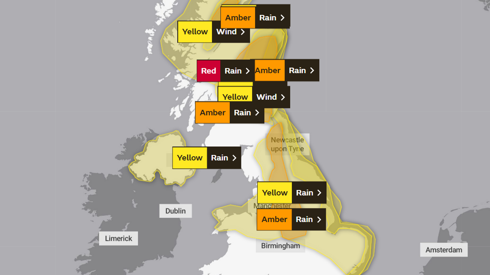
Scotland is bearing the brunt of Storm Babet, with hundreds forced to evacuate due to flood risk.
The bad weather is expected to sweep south, with much of the UK under severe weather warnings in the run-up to the weekend.
Here is a list of warnings, where the bad weather is expected to hit and when.
Check your local forecast by putting your postcode in here
Amber rain warning – midnight Thursday to 6am Saturday
This covers the following areas:
East Midlands
North East England
North West England
South west Scotland
Lothian Borders
West Midlands
Yorkshire and Humber
The warning means there will be persistent heavy rain that brings the likelihood of some flooding and disruption.
In most areas between 40 and 60mm of rain is likely to fall, according to the Met Office.
But the east-facing high ground from southeast Scotland to the Cheviots on the border with Northumberland, and south to the Peak District, may see between 80 and 120mm of rain locally.
Strong easterly winds may exacerbate the impacts of the heavy rain, the Met Office warns.
Yellow rain warning – midnight Thursday to 6am Saturday
This covers the following areas:
East Midlands
East of England
North East England
North West England
Wales
West Midlands
Yorkshire and Humber
Heavy rainfall is expected as two bands of rain merge.
The Met Office said: “A band of heavy and persistent rain is expected to slowly edge southwards across northern England into Friday, merging with a new area of rain pushing north from the southern North Sea.”
Most areas can expect 25-50mm of rain, but some parts of the North York Moors and Lincolnshire Wolds could see 50-80mm.
Parts of north Wales, particularly Snowdonia, could also see more than 100mm of rain.
Again, strong winds could make the impacts of the heavy rain worse.
Read more:
Storm Babet forces evacuations in red alert area
Yellow rain warning – 3am Friday to 6am
A yellow warning is also in place for Northern Ireland, covering:
County Antrim
County Armagh
County Down
County Fermanagh
County Londonderry
County Tyrone
There will be showers in eastern areas of Northern Ireland from late Thursday which are likely to become more widespread, persistent and heavy through Friday.
There “remains some uncertainty” about how much rain can be expected, but the Met Office said most of Northern Ireland will see 10-30mm.
“However, parts of the east could see 40-50mm, with as much as 60-80mm for the east-facing slopes of the Mournes and Antrim Plateau,” it added.
Blustery easterly winds could also be a hazard.
Be the first to get Breaking News
Install the Sky News app for free
Yellow wind warning – 12pm Friday to midday Saturday
Strong easterly winds will continue to affect coastal parts of eastern Scotland and England through Friday and Saturday.
The warning covers these areas:
Central, Tayside and Fife
East Midlands
East of England
Grampian
North East England
South west Scotland
Lothian Borders
Yorkshire and Humber.
Coastal easterly gales, accompanied by gusts of 40 to 60 mph are likely and could extend a short way inland and affect other higher ground areas inland too, the Met Office said.
The gales will be accompanied by large waves and dangerous coastal conditions, the forecaster warned.


