Forecasters have warned a rare weather feature called a sting jet could make Britain’s second storm this week even more dangerous than the first.
Storm Eunice is due to hit the UK and Ireland in the early hours of Friday morning, with severe wind warnings in place for most of the country from 3am.
The Met Office says strong winds of up to 100mph are likely to cause flying debris, building roofs to fly off and power lines to be brought down.
Heavy warnings issued by Met Office; live UK weather updates
Gusts could reach 100mph, particularly if an unusual phenomenon known as a sting jet occurs.
Here Sky News explains what a sting jet is, how it forms and how likely it is with Storm Eunice.
What is a sting jet?
A sting jet is a small area of extremely intense wind that can form inside storms passing over the UK, Ireland and parts of north and central Europe.
Relative to the size of the storm they are very narrow – usually only around 30 miles across – and tend to last just three or four hours.
But creating winds of at least 100mph, they are extremely dangerous and create significant risk to life.
They are rare and were only formally recognised when one occurred during the Great Storm of October 1987 – when wind speeds reached 115mph and millions of trees were brought down.
How do they form?
Non-tropical storms are caused by areas of low pressure that create weather fronts.
These fronts separate into areas of cold and warm air – and the way they interact with one another is what causes bad weather.
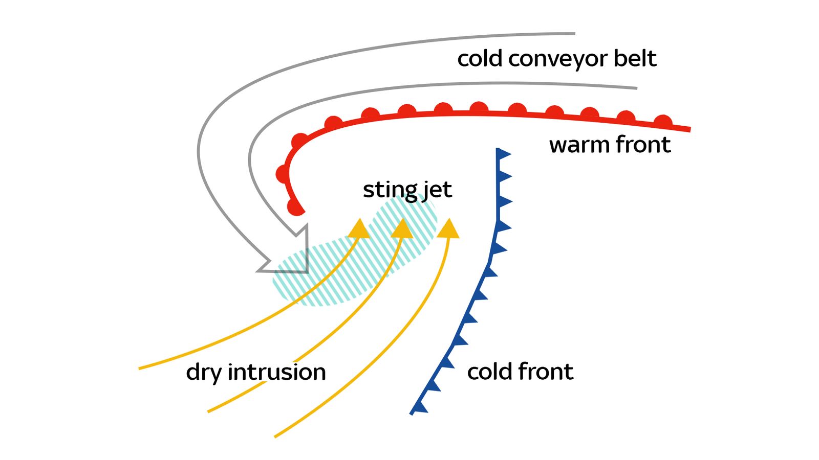
Ahead of the two fronts – focused streams of air called conveyor belts form.
Check the weather forecast in your area
The cold conveyor belt – a strong stream of cold air – pulls down into the storm ahead of the warm conveyor belt – also known as a dry intrusion.
Cold conveyors bring snow and rain, which evaporate and speed up the stream of cold air falling into the storm even more.
This is known as a sting jet – the ‘sting in the tail’ of the storm.
How rare are they?
Sting jets are difficult to forecast because of their small size relative to the overall storm.
They were only formally discovered following the Great Storm of 1987 and have only happened a handful of times since.
But the biggest sign of a sting jet is high winds.
After the storm starts to develop they can also be spotted on satellite images as the end of the cold conveyor belt forms a hook-shaped cloud that looks like the sting of a scorpion’s tail.
How likely is a sting jet with Storm Eunice?
The prediction of “extremely strong winds” when Eunice hits the UK on Friday suggests they may be fast enough to result in a sting jet.
But even if the rare weather event doesn’t happen, the winds caused by Eunice have the potential to be extremely damaging.
Looking ahead to #StormEunice on Friday, we are expecting to see even more dangerous weather conditions moving in 💨
Here are the forecast wind gusts 👇 pic.twitter.com/n7OHiU7vLJ
The Met Office is warning of “prolonged” power cuts, uprooted trees, damage to buildings and homes and “significant” travel disruption.
An amber warning covers England and Wales between 3am and 9pm on Friday, while northern parts of England, southern Scotland and Northern Ireland have a slightly less severe, yellow warning lasting from 3am to 6pm.
The most severe red-level warning covers the South West of England and parts of South Wales between 7am and midday.
The Met Office issues weather warnings when severe weather is likely and has the potential to disrupt day-to-day life.
These are colour-coded yellow, amber and red to reflect both how likely the extreme weather is and how badly it could impact people.
They only cover the parts of the country affected and last for a period of hours or sometimes days. Most often they are for rain, wind, snow and heat.
Yellow warnings are usually issued when bad weather is due but the impact on daily life will be relatively small.
Disruption will likely involve travel delays, loss of electricity and water supplies, and minor damage to buildings.
They can also be used when the impact of the weather could be much more severe – and even endanger life – but is less likely.
Amber warnings mean the weather is much more likely to disrupt your plans.
It could result in travel delays and cancellations, power cuts and risk to life and property.
Forecasters will ask people to consider changing their plans to minimise risk.
Red weather warnings are the most severe and mean dangerous weather is likely.
They are likely to mean complete disruption to travel, loss of power and water, and significant damage to homes and businesses that is likely to endanger life.
When a red warning is issued forecasters urge people to take immediate plans to protect their homes and businesses and avoid any travel where possible.


